


#MD62
Ca. 1820s
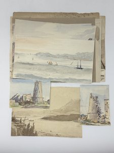
Eleven watercolour and two pencil drawings, mostly larger ones from ca. 24x30 cm (9 ½ x 11 ¾ in) to ca. 15x27,5 cm (5 ¾ x 10 ¾ in); two smaller drawings are ca. 10x13,5 cm (4 x 5 ¼ in). All with period ink captions on verso. One drawing with a pencil date “1824,” one with an ink date “April 7, 1825” in the right lower corners. One drawing is mounted on a period album leaf. Paper of two pencil drawings slightly age-toned, several minor tears on extremities, but overall a very good collection.
Attractive collection of thirteen original drawings of Gibraltar and its environs, made by a notable British military officer and politician, James Bucknall Estcourt, during his service on the Rock in the mid-1820s.
Estcourt was born in the family of British politician Thomas Grimston Estcourt (1775-1853) and was educated at Harrow School. He entered the army in 1820 and four years later was sent to Gibraltar with the 43rd Monmouthshire light infantry regiment, where he spent several years, creating a series of drawings of Gibraltar and its environs. Later, he served in Ireland, was second-in-command during Colonel F. Chesney’s Euphrates Valley Expedition (1835-1837), participated in the suppression of the Lower Canada Rebellion, and served as British boundary commissioner during the delineation of the border between British North American colonies and the state of Maine (1842-1844). In the late 1840s, he served in the British Parliament and joined the British expeditionary force during the Crimean War (1853-1855).
The drawings depict various sites of British settlement and fortifications on Gibraltar, including O’Hara’s Tower (was located on the highest point of the Rock, demolished in 1888), St. George’s Hall (the interior featuring the artist, supplemented with a lengthy manuscript annotation on verso), Ragged Staff guard house (interior of officers’ room), Gibraltar harbour taken from the New (South) Mole, Cabrita Point, &c. The drawings feature several local landmarks (Charles V wall, Apes Hill, Moorish Castle), as well as Spanish towns and sites on the shores of the Bay of Gibraltar (San Rogue, Castellar de la Frontera, Algeciras, Guadarranque River, Sierra Carbonera). One of the drawings depicts soldiers of the “Forty-Third” [Monmouthshire light infantry regiment] performing a military exercise in Gibraltar. Overall, a nice collection of early original watercolour and pencil drawings of Gibraltar.
A list of drawings (after the manuscript captions on verso):
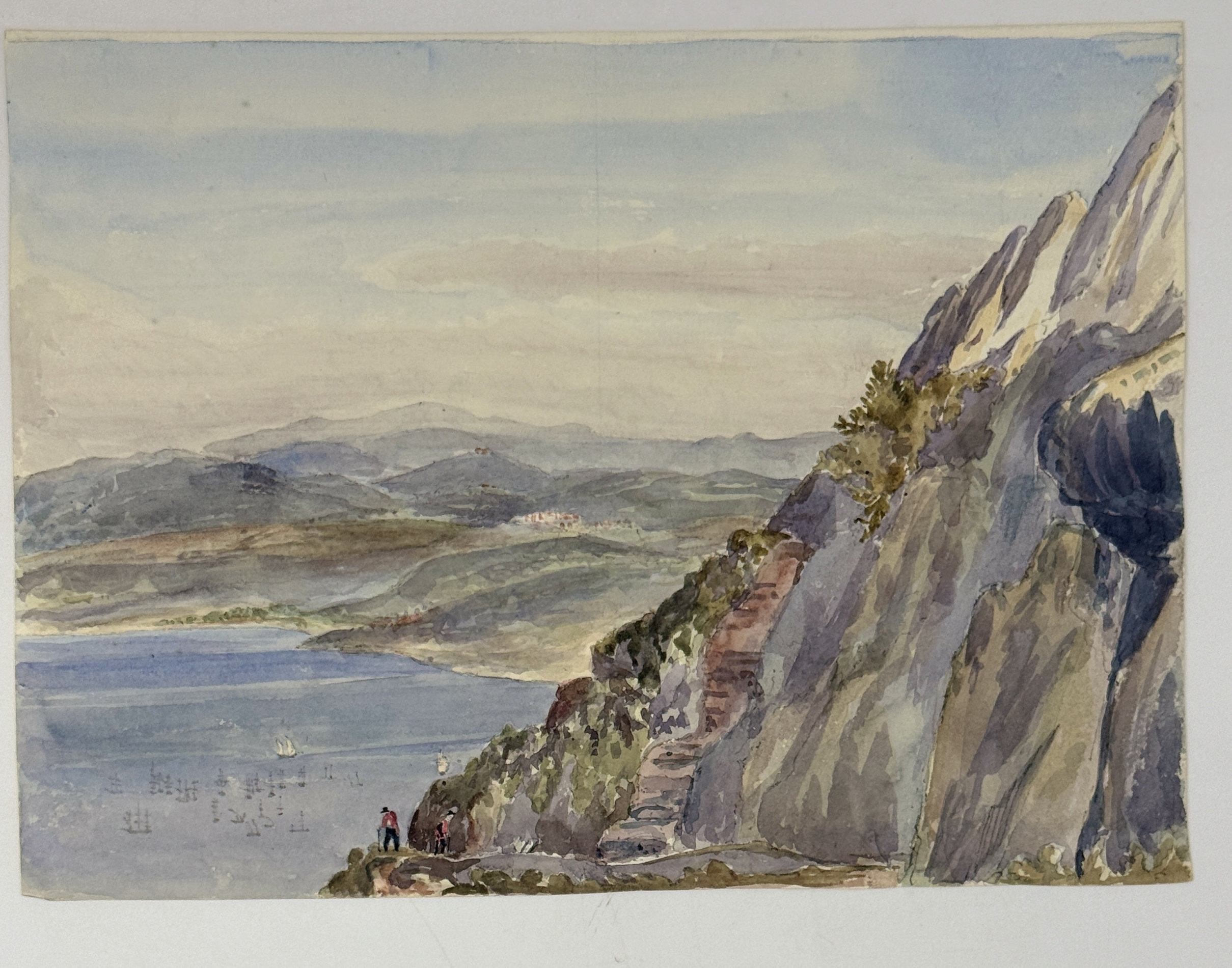
“No. 5 shews the bay as it approaches nearer to Gibraltar. San Rogue and Castellar may be seen in the distance, the latter situated at the summit of a conical hill. In the foreground two figures are seen ascending by the road up the Rock; but they appear sadly tired by their exertions.” Watercolour ca. 20x27,5 cm (8 x 10 ¾ in).
“No. 6. Represents O'Hara's Tower, from whence all the preceding sketches have been taken. It was built by General O’Hara with a view of gaining a sufficient height as to be able to see into the Bay of Cadiz. It was deemed a foolish undertaking and never completed; it has been frequently struck by lightning and once since I have been here. Copied.” Watercolour ca. 10x13 cm (4 x 5 ¼ in).
“No. 8. Is also a view of O'Hara's Tower taken from the corner of the guard house. Apes Hill shows itself over the parapet wall. The fore building in all these sketches is merely the small space before the tower, having a small parapet wall to enclose it.” Watercolour ca. 10x13,5 cm (4 x 5 ¼ in).
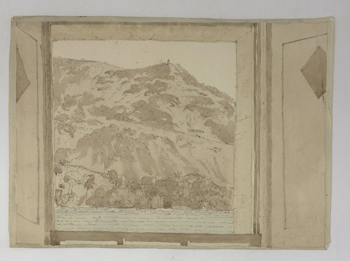
“No. 10. Is a view of Cabrita Point with Tangier Bay in the distance; Cape Spartel is hid by Cabrita Point. This is also from my window.” Watercolour ca. 15x27,5 cm (5 ¾ x 10 ¼ in).
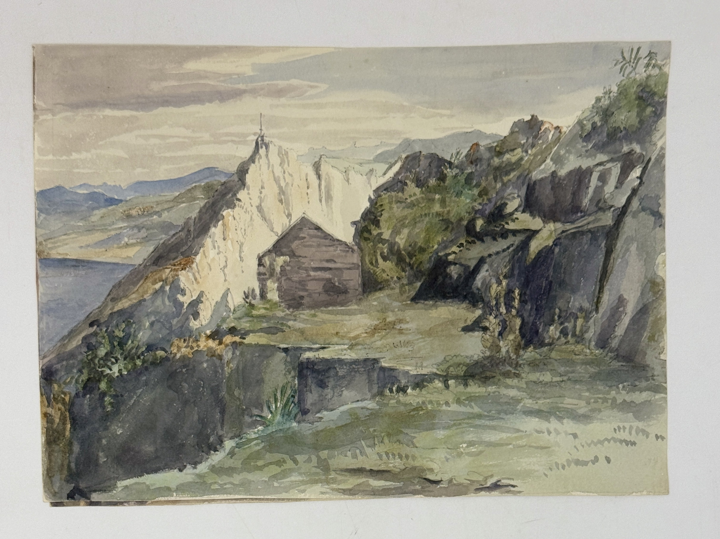
“No. 11. Is a view taken from nearly the top of the Rock about halfway between O’Hara’s tower and the Signal House which you see, with the east face of the Rock. Charles 5th wall, San Rogue in distance.” Watercolour ca. 19,5x27,5 cm (7 ¾ x 10 ¼ in).
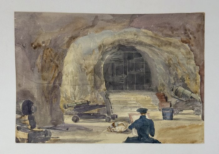
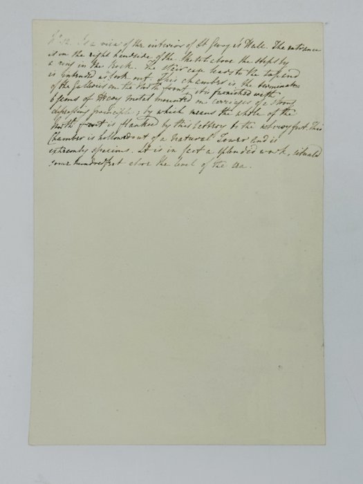
“No. 12. Is a view of the interior of St. George’s Hall. The entrance is on the right hand side of the sketch above the steps by a ring in the Rock. The staircase leads to the top and is intended as lookout. This chamber is the terminal of the galleries on the North front, it is furnished with 6 guns <…> mounted on carriages <…>; by which means the whole of the North front is flanked by this battery to the very foot. This chamber is hollowed out of a natural tower and is extremely spacious. It is in fact a splendid work, situated some hundred feet above the level of the sea.” Watercolour ca. 18,5x27 cm (7 ¼ x 10 ½ in). The artist is depicted making a sketch in the foreground.
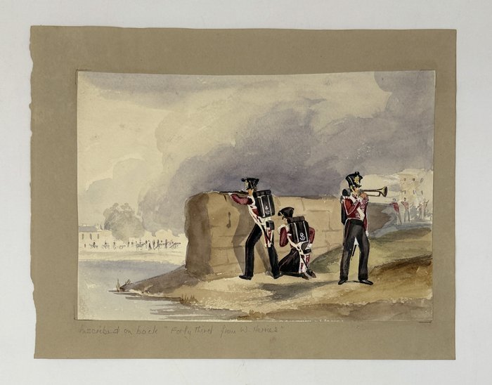
“Forty-third from […?].” Watercolour ca. 17x24 cm (6 ¾ x 9 ½ in). Depicts a scene with three British soldiers on a military exercise in Gibraltar.
“Castellar with Gibraltar in the distance.” Watercolour ca. 20x28 cm (7 ¾ x 11 in).
“The ferry across the River Guadaranque and Algeciras in the distance.” Brown sepia watercolour ca. 17x24 cm (6 ½ x 9 ½ in). Shows Spanish ferry on the Guadarranque River and the town of Algeciras on the western shore of the Bay of Gibraltar.
“A view of O'Hara’s Tower from my room in the North [Position?] in the South barracks, Gibraltar.” Brown sepia watercolour ca. 22x30,5 cm (8 ½ x 12 in).
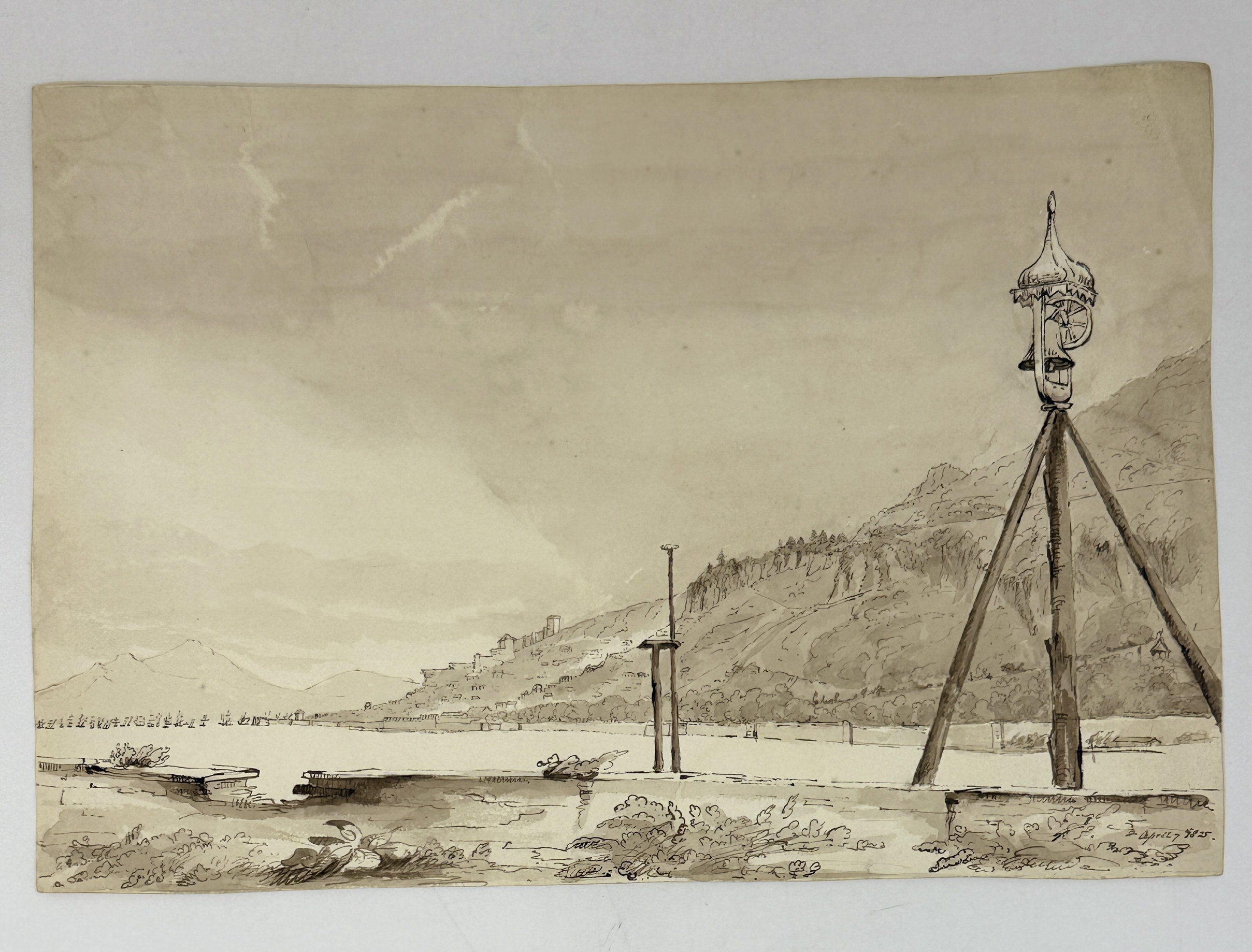
“A view from the New [South] Mole, Gibraltar.” Brown sepia watercolour ca. 22,5x33,5 cm (9 x 13 ¼ in). Dated “April 7, 1825” in the right lower corner. Shows Gibraltar Harbour from the South Mole looking north; the Moorish Castle and hills of Sierra Carbonera on the Spanish territory are seen in the background.
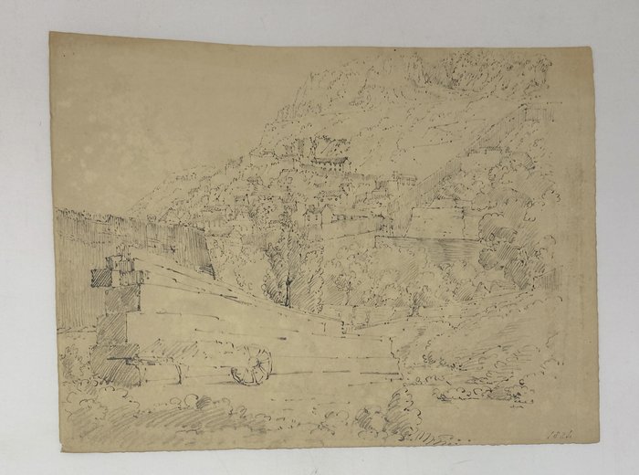
“South Part, Gibraltar from Ragged Staff.” Pencil drawing ca. 21x28,5 cm (8x11 in). Dated “1824” in pencil in the right lower corner.
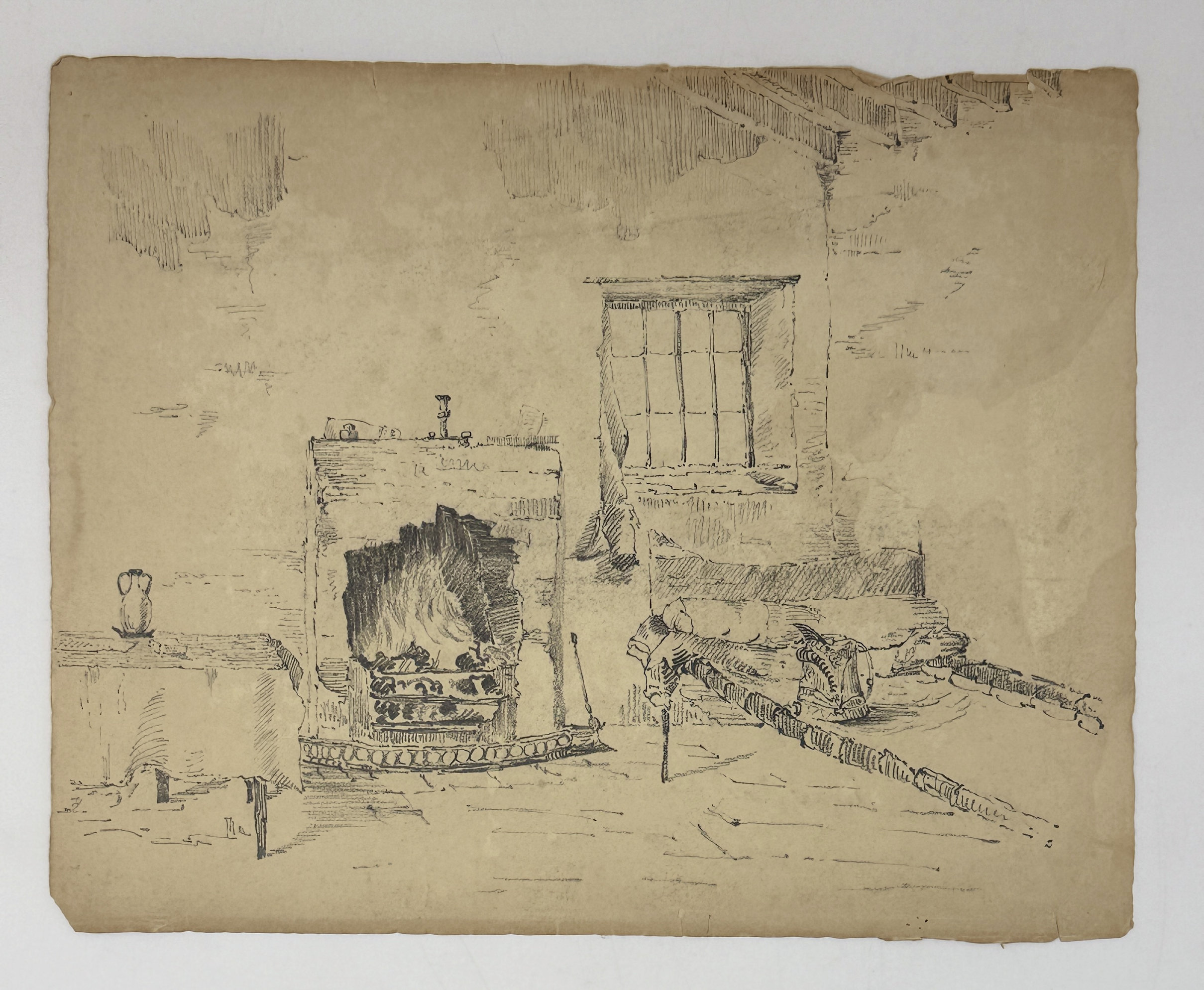
“Interior of the Officer's Guard Room at Ragged Staff, Gibraltar.” Pencil drawing ca. 24x30 cm (9 ½ x 11 ¾ in).