#O96
1855
[Washington DC]: 1855. Engraved map ca. 55 x 57,5 cm (22.5 x 22 inches). Drawn by W.B. Mc Murtrie; Reduction for engraving by A. Lindenkohl. Engraved by G. McCoy, J.V.N. Throop & App. J.J. Knight. Slightly age-toned and with some minor repair at fold, otherwise a very good map.
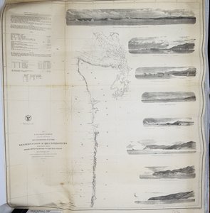
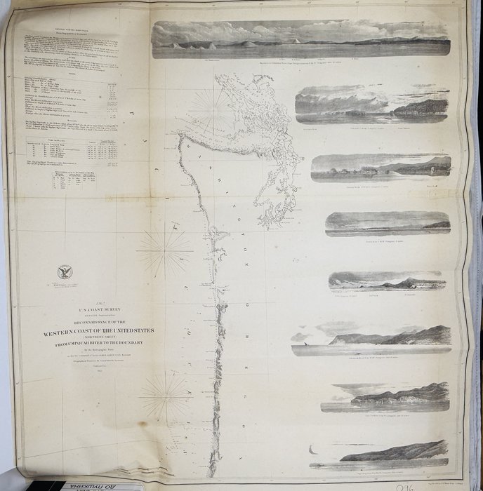
One of the three maps issued after the first official scientific survey of the US Pacific coast. The map is supplemented with 8 coastal profiles (Entrance to Columbia River, Flattery Rocks, Destruction Island, Tillamook Head, Cape Lookout, Cape Perpetua et al); text of "General Sailing directions from Umpquah River Northward"; observations of tides, and a Table of Latitudes and Longitudes.
"This terrific chart <//,> covers the region from the boundary with Canada south past the Columbia River, Cape Foulweather and south to the Umpquah River near today's Reedsport and the historical Umpquah Lighthouse. Good detail of soundings in the complex waterways of the Straits of Juan de Fuca, the San Juan Islands, the Gulf of Georgia and Puget Sound. The chart outlines the coastal littoral, shows dangerous reefs and shoals, gives offshore bathymetric soundings, plus general and specific harbor sailing instructions. The most impressive feature is the eight views of entrances and promontories along this rugged coastline - among them, Flattery Rocks, Tillamook Head, Destruction Island, Cape Lookout and the entrance to the Columbia River and Cape Disappointment. One of the finest Coast Survey charts produced" (Old World Auctions).