
#RA20
1828
2 vols in one. First edition. Large Quarto (ca. 29x22,5 cm). [2 - t.p., [2 – table of contents], iii, 321, [1 - errata]; [2 - t.p.], [2 – table of contents], 251, [1 - errata] pp. With a complete set of illustrations, as follows: vol. 1 with eleven copper-engraved maps and plans (including four folding); vol. 2 with nine copper-engraved maps and plans (including four folding) and fourteen coastal profiles. Period style brown half straight-grained morocco with marbled papered boards; spine with gilt-lettered title and gilt-tooled decorations. A number of leaves with pre-1917 Revolution markings of “Belomorskaya S’yomka” [Survey of the White Sea]. One leaf with repair of blank margin and one leaf with a minor tear neatly repaired, occasional ink markings in text, margins slightly trimmed, but overall a very good copy of this rare book.
Very Rare Russian imprint with only six paper copies found in Worldcat (New York Public Library, Yale University, University of Alaska Fairbanks, State Library of Berlin, Erfurt University, National Library of Scotland).
The first book by a famous Russian Arctic and Pacific explorer, one of the founders of the Russian Geographical Society (1845), a member (1829) and later President (1864-1882) of the Russian Academy of Sciences, Friedrich von Luetke. Issued on the special order of Russian Emperor Nicholas I, whose Privy Purse paid for the publication (Zapiski, izdavaemye Gosudarstvennim Admiralteiskim Departamentom… Vol. XII. SPb: Morskaya Typ., 1827, p. xxvii), the book is the only official account of Luetke’s Arctic expedition in 1821-1824. The expedition explored and mapped the west coast of Novaya Zemlya up to Cape Nassau, Matochkin Shar Strait, Kolguyev Island, the eastern coast of the mouth of the White Sea, including Kanin Nos Peninsula, and Murmansk coast of the Barents Sea between Orlov Nos Cape in the south and Norwegian Varanger Peninsula and Vardoya Island in the north. Although Luetke didn’t manage to explore the east coast of Novaya Zemlya due to pack ice, his expedition became the first scientific voyage to the region, which laid the base for future hydrographic research by Michael von Reineke (1801-1859). At the time, Luetke surveyed the longest stretch of the coast of Novaya Zemlya; he also significantly corrected the map of the White Sea and the Murmansk coast of the Barents Sea (see: Bezobrazov, V.P. Graf Fedor Petrovich Litke. SPb., 1888, pp. 104-107). After the publication, Luetke started to correspond with several European scientists, including a noted naturalist and geographer, Karl Ernst von Baer (1792-1876). Luetke and Baer became close friends, and it was by Luetke’s influence that Baer went on a scientific journey to Novaya Zemlya in 1837, becoming the first naturalist to visit the archipelago.
Luetke’s account was published with a small print run of 600 copies and quickly became a bibliographic rarity. It was translated into German in 1835 (Viermalige Reise durch das nördliche Eismeer auf der Brigg Nowaja Semlja in den Jahren 1821 bis 1824 ausgeführt vom Kapitain-Lieutenant Friedrich Litke/ Transl. by Adolf Erman. Published as vol. 2 of “Kabinets-Bibliothek der neuesten Reise und Forschingen im Gebiete der Länder-, Völker- und Staatenkunde, herausgegeben von Dr. Weinrich Berghaus.” Berlin, 1835). The second Russian edition was issued only in 1948 (Litke, F.P. Chetyryokhkratnoye puteshestviye v Severnyi Ledovityi Okean na voyennom brige “Novaya Zemlya” v 1821-1824 godakh. M: Geografgiz, 1948). No English edition has been issued so far.
This copy bears several ink stamps of the Russian Imperial Commission on the hydrographical survey of the White Sea (“Belomorskaya S’yomka”), which operated in 1887-1916 to further explore, survey and provide safe navigation in the region. The commission worked for a few years after the Revolution of 1917 under the name “Hydrographical Expedition of the White Sea” (closed in 1922) which likely meant that the library was dispersed in 1922.
Overall, an attractive copy of this rare official account of Friedrich von Luetke’s expedition to the Arctic Ocean in 1821-1824 with an interesting Arctic provenance.
“Account of earlier expeditions to Novaya Zemlya and their contributions to the mapping of the west coast (v. 1, p. 1-123), followed by narrative (in journal form) of author’s four summer trips from Archangel to the west coast of Novaya Zemlya for the purpose of mapping it. Data on coasts, harbors, and the coordinates of various points from the southern tip to about 76°30’N are given. Similar work was done on northern coast of Kola Peninsula (1822-23), in Matochkin Shar Strait, and at Kolguyev Island. Day-to-day comments on the weather, state of sea or ice, and currents, when observed. Information on depths, including White Sea (with location of bars) and delta of Pechora River as furnished by Demidov (v. 2, p. 143-199) and Ivanov (v. 2, p. 200-51) acting under Litke’s orders. Ivanov also described the coast from Pechora to Vaygach Island. Some information on the Lapps and Samoyeds is included” (Arctic Bibliography 10212, vol. II, Washington, D.C., 1953, p. 1527).
“In 1821-24 he made four attempts with the brigantine New World to circumnavigate Novaya Zemlya from the north. Although exceptionally heavy ice prevented success, the expedition contributed much to the science. Important mistakes on maps on the position of the western coast of Novaya Zemlya, Matochkin Shar, Kanin Nos, the eastern coast of the mouth of the White Sea, and the Murmansk coast of the Barents Sea were investigated with the aim of determining the possibility of using them for anchorage; and extensive areas of the Barents Sea were studied, including its northern part, between Spitsbergen and Novaya Zemya. Most of the western coast as far as Cape Nassau was charted, as well as Matochkin Shar, and for many years part of the coast was known as Litke Land” (Howgego, 1800 to 1850, L37).
“The rare first edition of Litke's survey of Novaya Zemlya: an important stage in establishing the Northeast Passage to the Pacific. RBH and ABPC record no copies having been offered at auction. The easternmost point in Europe, Novaya Zemlya separates the Barents Sea from the Kara Sea – a body of water long thought to be impenetrable. This expedition made four attempts to circumnavigate Novaya Zemlya from the north, each one prevented by exceptionally heavy ice. But it made important contributions to the Northeast Passage project, correcting significant mistakes in the positions of landmarks such as the Matochkin Strait, studying extensive areas of the Barents Sea, and mapping-out possible anchorages. Litke had participated in Golovnin's around-the-world voyage on board the sloop "Kamchatka" (1817-1819), and it is Golovnin that recommended that Litke be put in charge of the Novaya Zemlya expedition” (Christie’s).
“With 34 maps and plates with [coastal] views. <…> The book was published on the Highest Order and printed in 600 copies” (Sokolov, Russkaya Morskaya Biblioteka, 1701-1851. SPb., 1883, No. 181, p. 183); “Rarity. Shibanov No. 103 – 50 roubles” (N.B. Russkiye Knizhnye Redkosti, Part. 1. Moscow, 1902, No. 308).
Eberstadt no. III-156; Howes, U.S. IANA no. L.375; Smith, J.S. Catalogue of Books [Slavica, in the Library of Yale University] 344; Tourville 2727; Wickersham 6269.
A list of maps and plates.
Vol. 1:
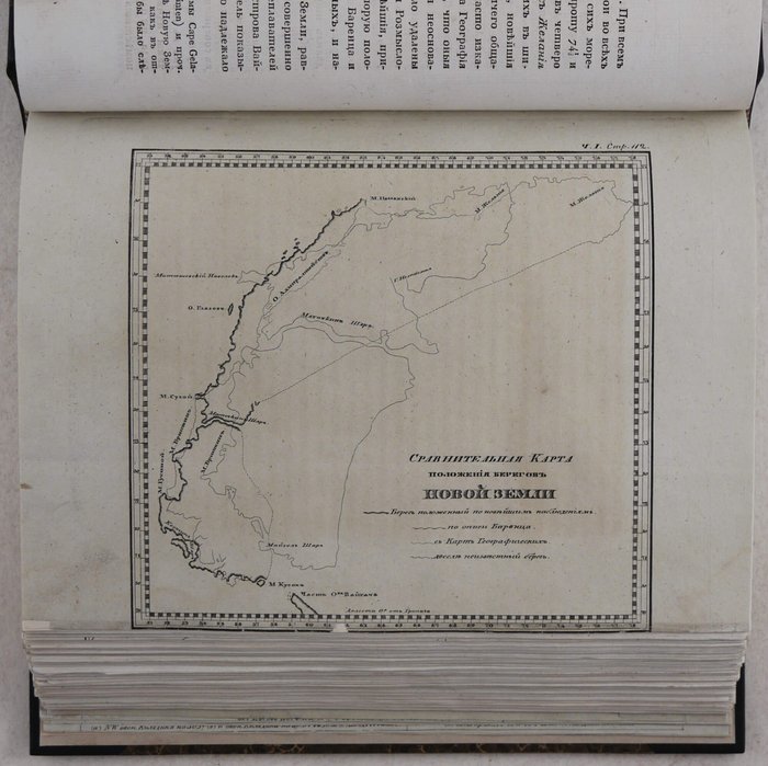
1) Sravnitelnaya karta polozheniya beregov Novoi Zemli [Comparative map of the position of the coast of Novaya Zemlya] (facing p. 112);
2) Karta reki Dviny ot Arkhangelska do vykhoda v Beloye Morye [Map of the Dvina River from Arkhangelsk to the entrance of the White Sea] (folding, facing p. 142);
3) Chastnaya karta reki Kuznechikhi ot ostrova Moiseeva do ostr. Kazametsa [A particular map of the Kuznechikha River from Moiseev Island to Kazamets Island] (facing p. 144);
4) Plan Beryozovogo Bara v ustye reki Dviny [Plan of the Beryozovyi Bar in the mouth of the Dvina River] (folding, facing p. 166);
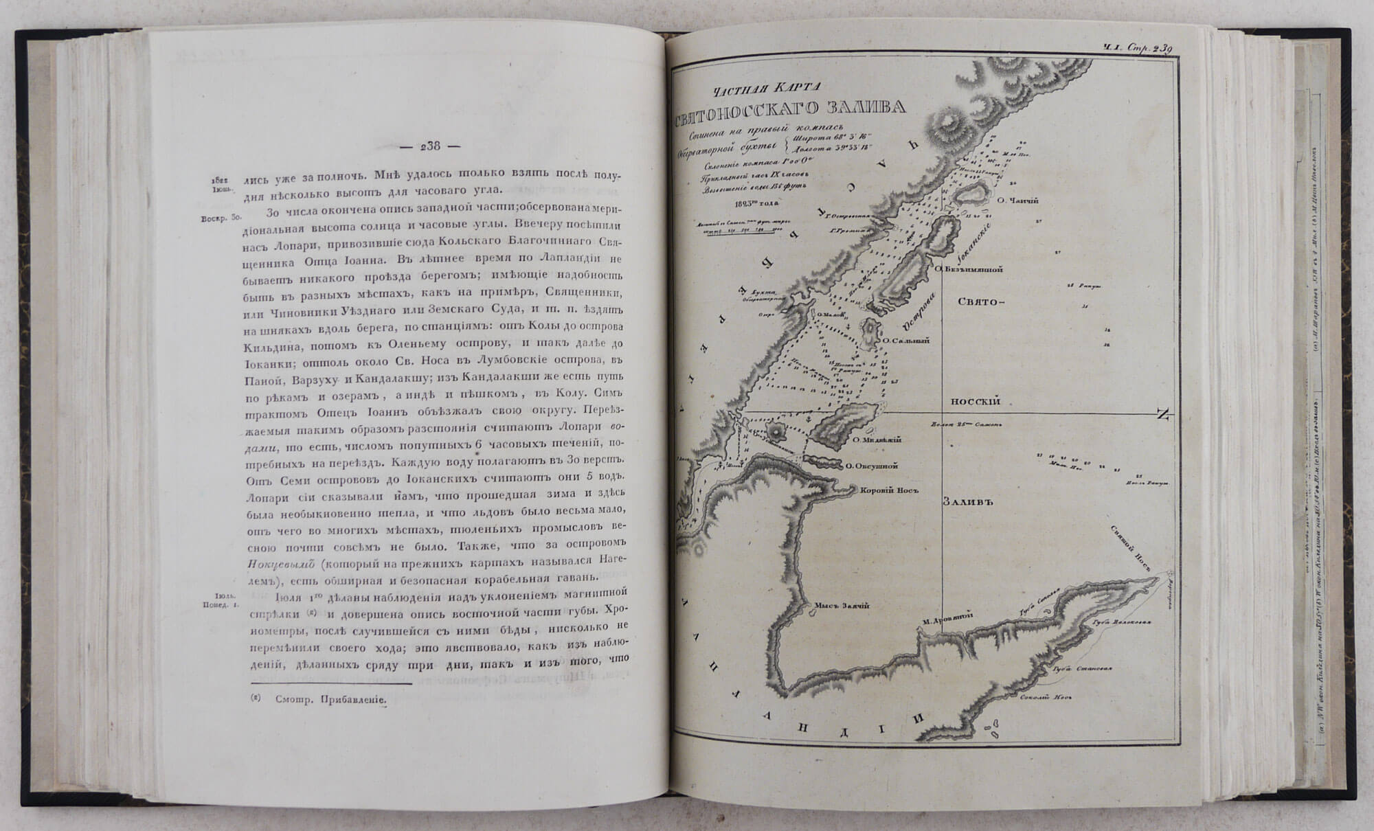
5) Chastnaya karta Svyatonosskogo Zaliva, 1823 [A particular map of the Svyatoy Nos Bay] (facing p. 238);
6) Chastnaya karta ostrova Nokuyeva, 1822 [A particular map of the Nokuyev Island] (facing p. 250);
7) Chastnaya karta Semi Ostrovov [A particular map of the Seven Islands] (folding, facing p. 256);
8) Chastnaya karta Olenyego Ostrova i prilezhaschikh yemy zalivov [A particular map of the Oleniy/Deer Island and the adjacent bays] (facing p. 266);
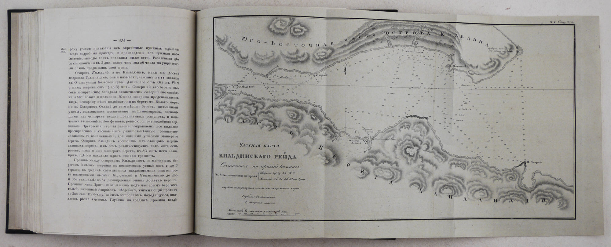
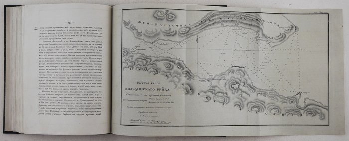
9) Chastnaya karta Kildinskogo reida, 1822 [A particular map of the Kildin Island roadstead] (folding, facing p. 274);
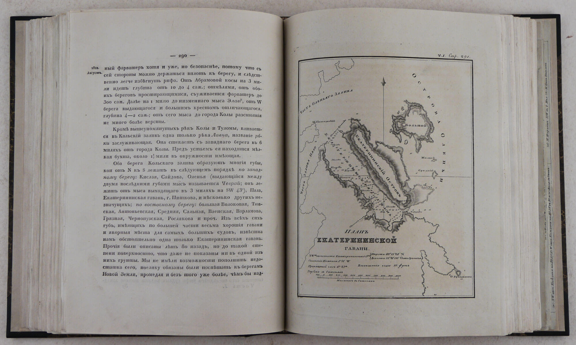
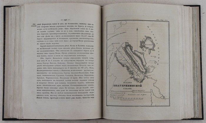
10) Plan Yekaterininskoi Gavani [A plan of the Yekaterininskaya harbour] (facing p. 290);
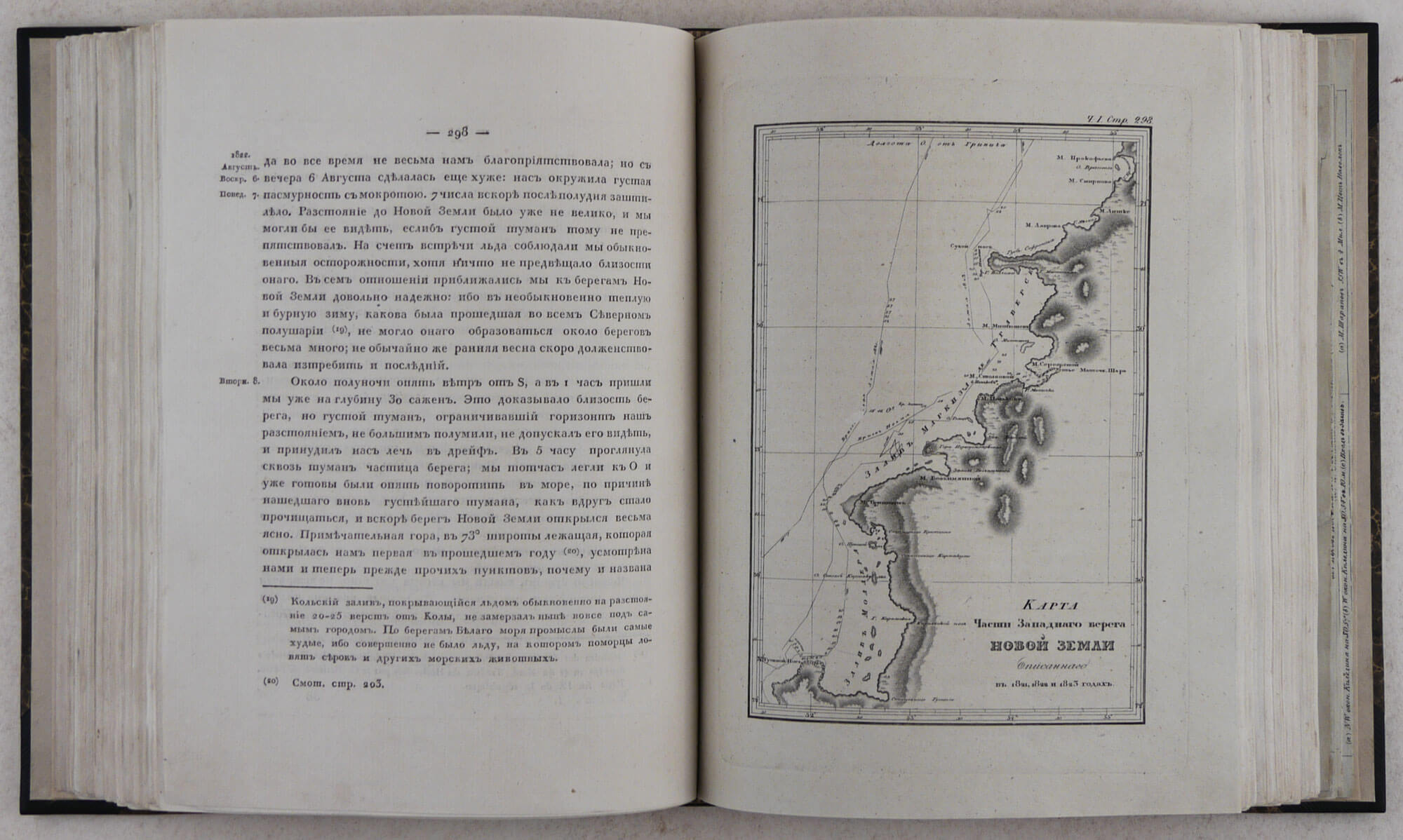
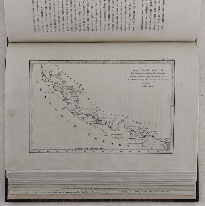
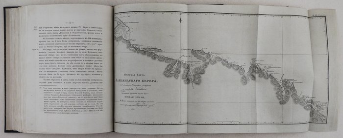
11) Karta chasti zapadnogo berega Novoi Zemli, opisannogo v 1821, 1822 i 1823 godakh [Map of a part of the western coast of Novaya Zemlya, described in 1821, 1822 and 1823] (facing p. 298).
Vol. 2:
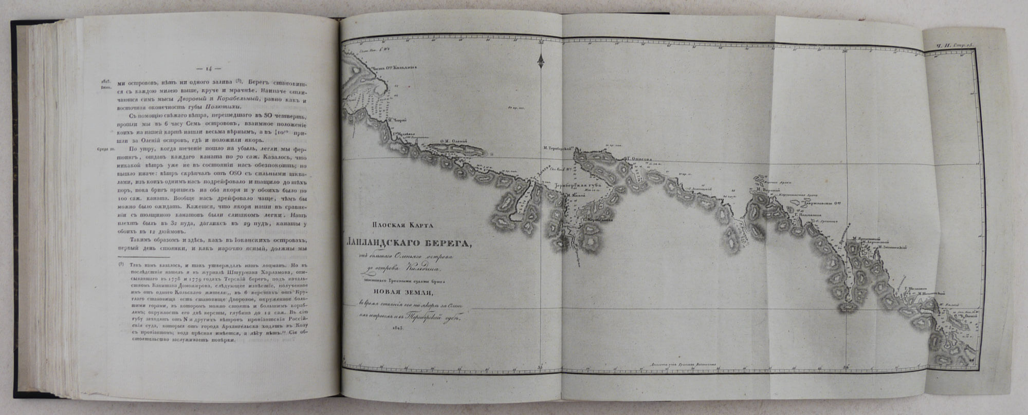
1) Ploskaya karta Laplandskogo berega ot Bolshogo Olenyego ostrova do ostrova Kildina, opisannogo grebnymi sudami briga Novaya Zemlya vo vremia stoyania yego na yakorie za Olenyim ostrovom i v Teriberskoi gube, 1823 [Flat/Mercator’s map of the Lapland coast from the Bolshoy Oleniy Island to Kildin Island, surveyed by the cutters of brig “Novaya Zemlya” during its stay behind the Oleniy Island and in the Teriberka Bay, 1823] (folding, facing p. 14);
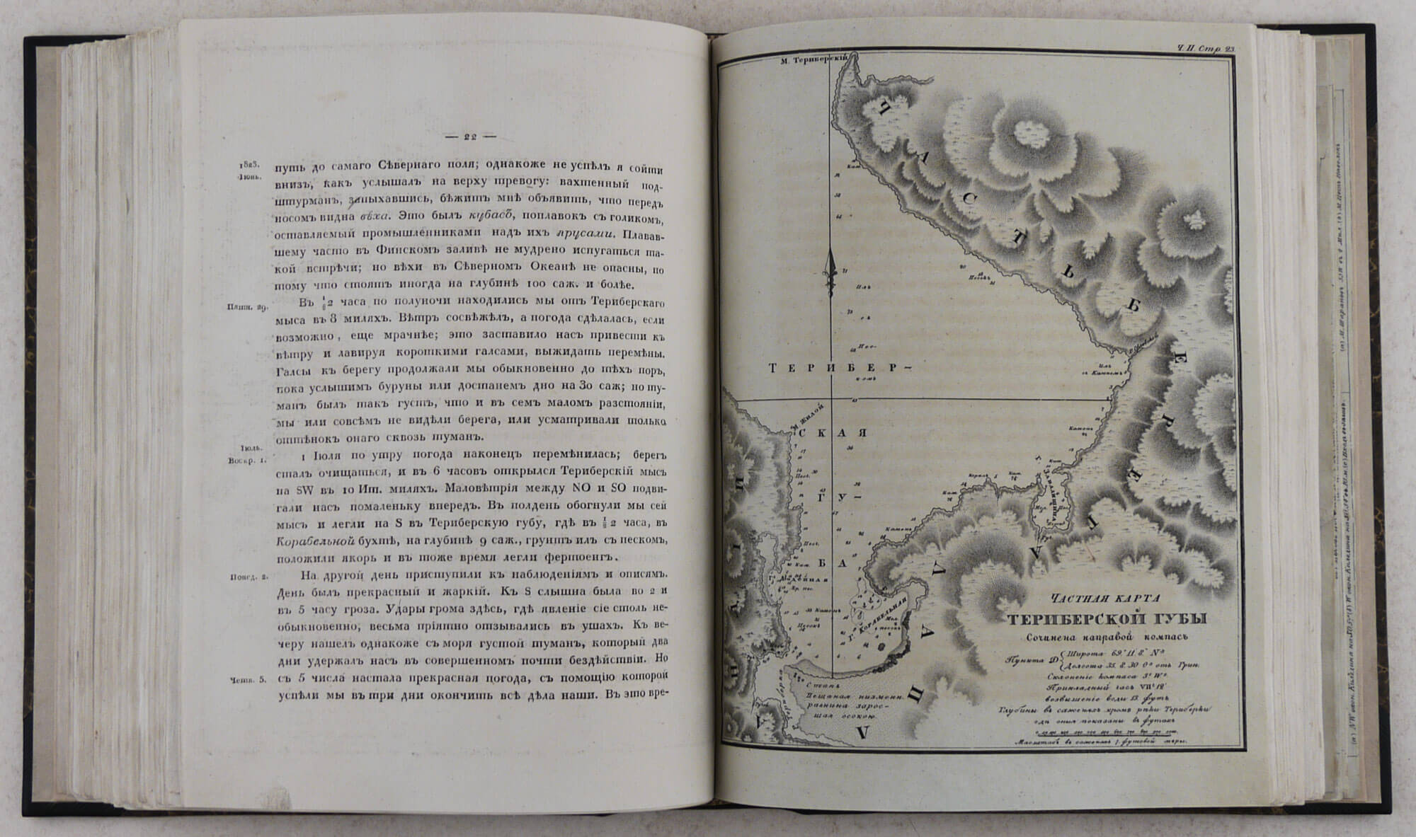
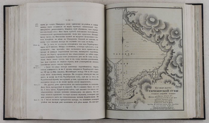
2) Chastnaya karta Teriberskoy guby [A particular map of the Teriberka Bay] (facing p. 22);
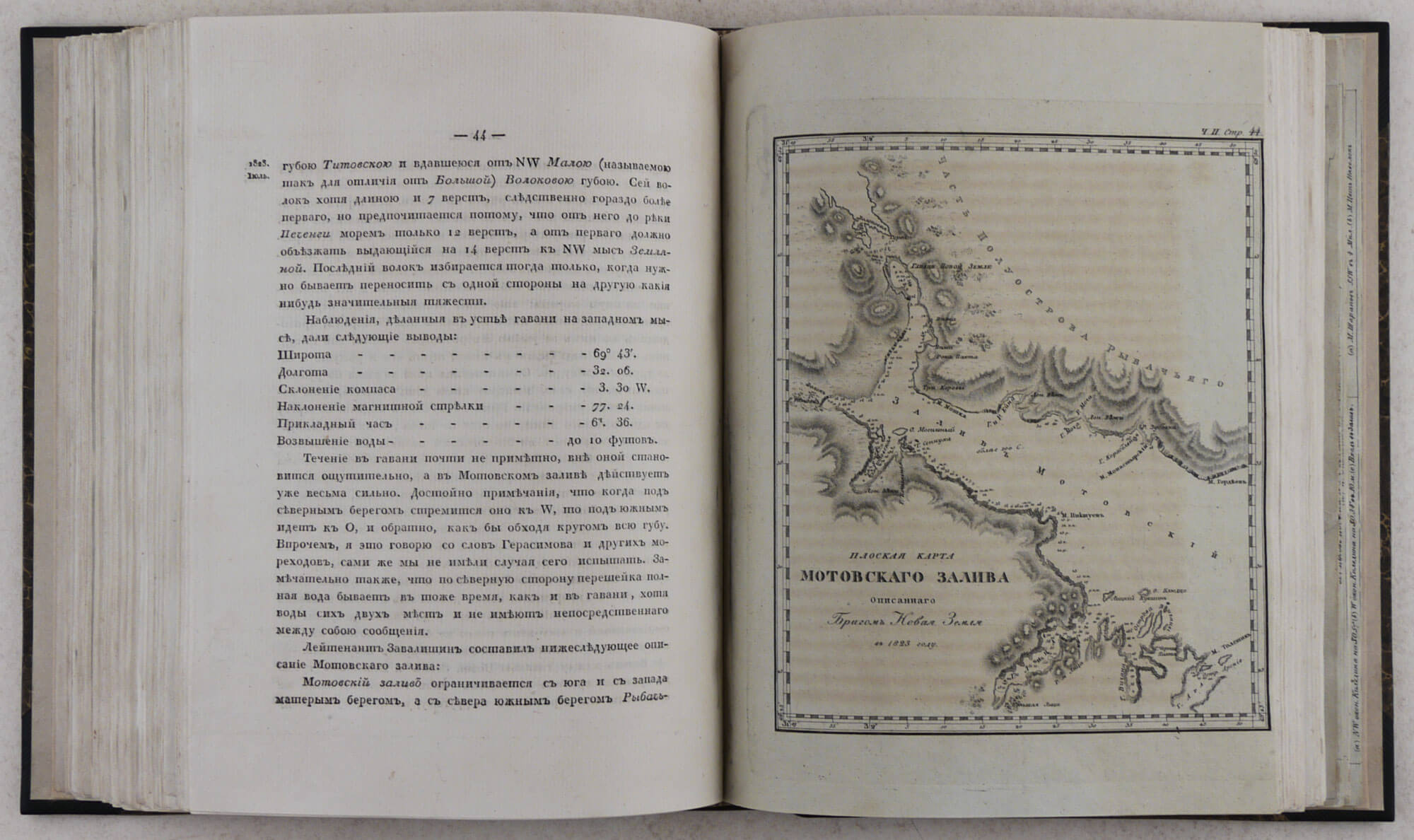
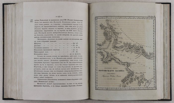
3) Ploskaya karta Motovskogo Zaliva, opisannaya brigom Novaya Zemlya v 1823 godu [Flat/Mercator’s map of Motovsky Bay, surveyed by brig “Novaya Zemlya” in 1823] (facing p. 44);
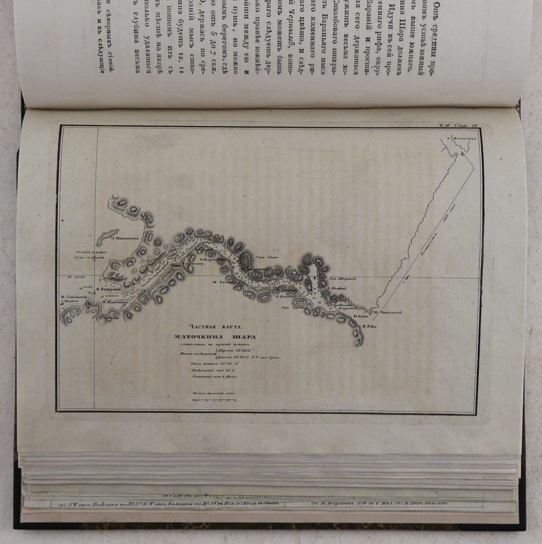
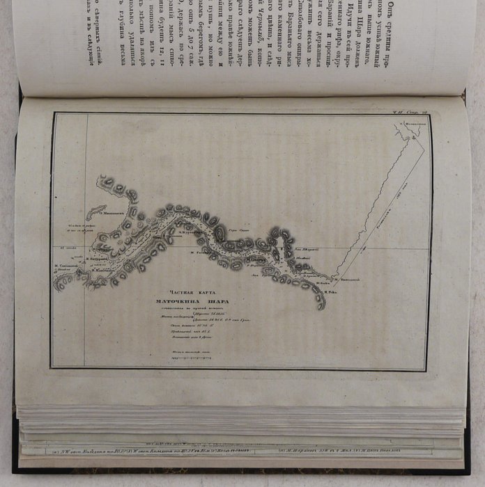
4) Chastnaya karta Matochkina Shara [A particular map of Matochkin Shar Strait] (facing p. 74);
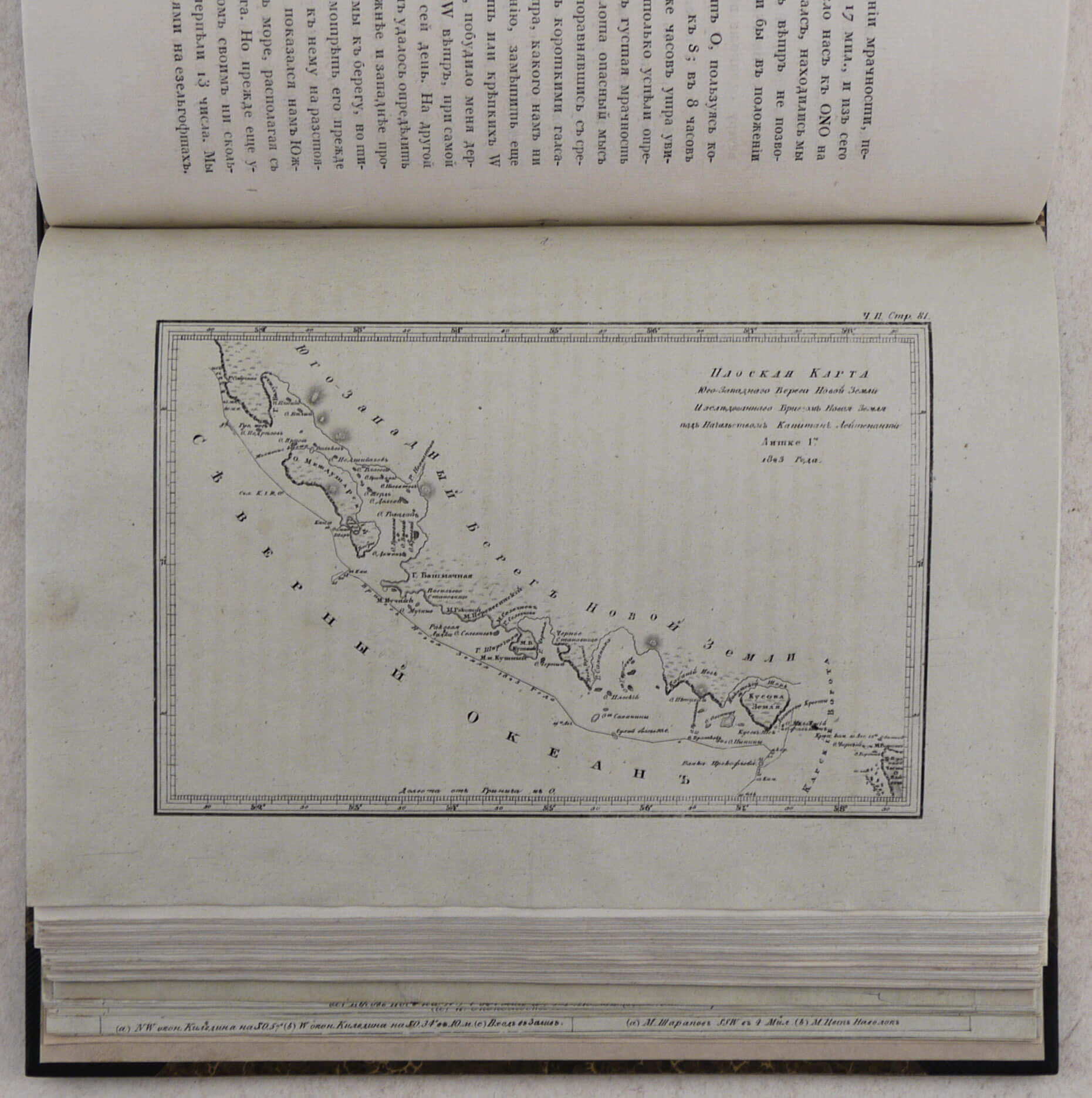
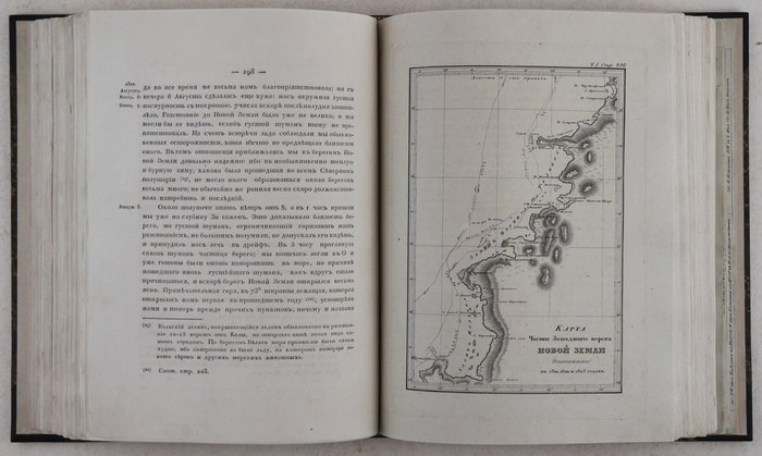
5) Ploskaya karta yugo-zapadnogo berega Novoy Zemli, issledovannogo brigom Novaya Zemlya pod nachalstvom Kapitan-Leytenanta Litke v 1823 godu [Flat/Mercator’s map of the southwestern coast of Novaya Zemlya, surveyed by brig “Novaya Zemlya” under command of Captain-Lieutenant Luetke in 1823] (facing p. 80);
6) Karta rek Chizhi and Cheshi po opisi ot flota za Leytenanta mastera Yevstikheya Bestuzheva i michmana Petra Mikhaylova, 1741 goda [A map of Chizha and Chesha Rivers, according to the survey of acting Fleet Lieutenant Yevskihey Bestuzhev and midshipman Peter Mikhailov, from 1741] (facing p. 150);
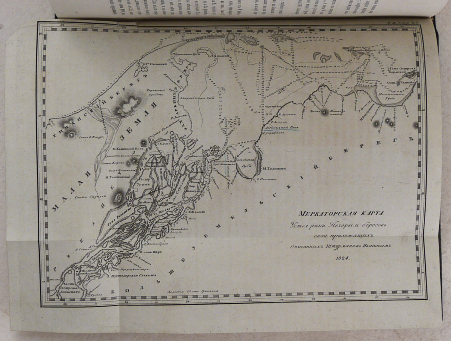
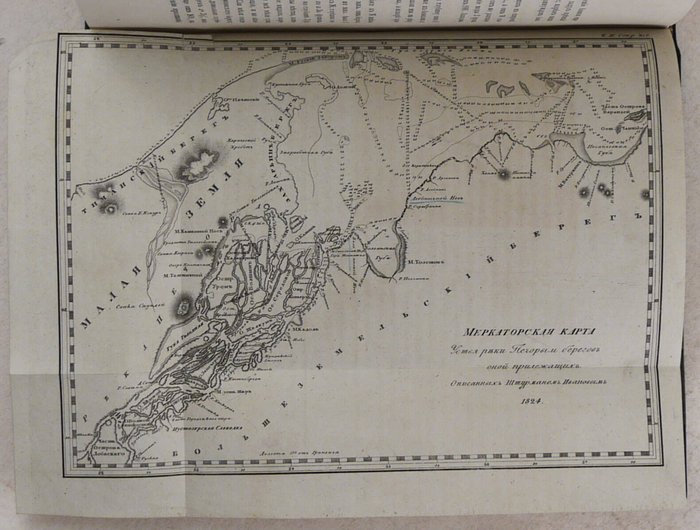
7) Merkatorskaya karta ustya reki Pechory i beregov onoi prilezhashchikh, opisannykh shturmanom Ivanovym, 1824 [Mercator’s map of the mouth of the Pechora River and the adjacent shores, surveyed by navigator Ivanov, 1824] (folding, facing p. 216);
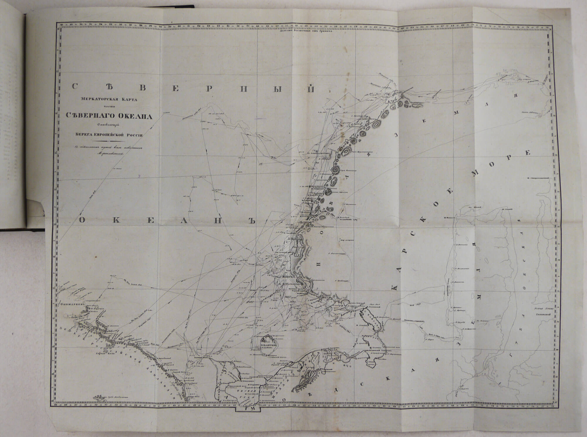
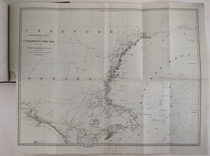
8) Merkatorskaya karta chasti Severnogo Okeana, omyvayushchey berega Yevropeyskoi Rossii, s pokazaniyem putey vsekh izvestnykh moreplavateley [Mercator’s map of the part of the Northern Ocean, washing on the shores of European Russia, with the tracks of all known navigators] (large folding, facing the verso of the errata page);
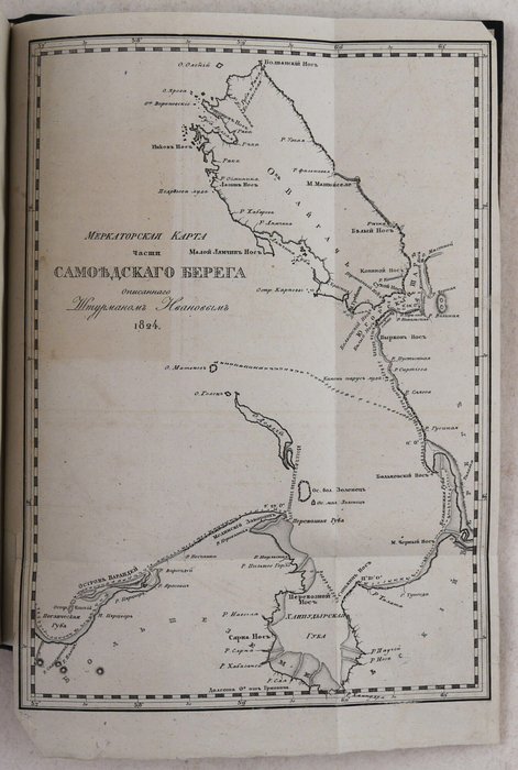
9) Merkatorskaya karta chasti Samoyedskogo berega, opisannogo shturmanom Ivanovym, 1824 [Mercator’s map of a part of the Samoyed coast, surveyed by navigator Ivanov, 1824] (folding, at the rear);
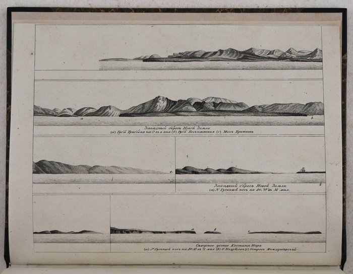
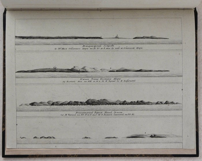
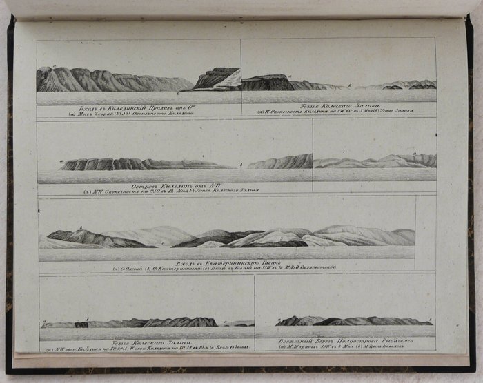
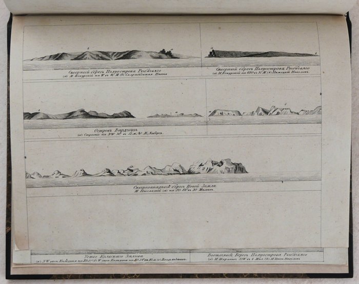
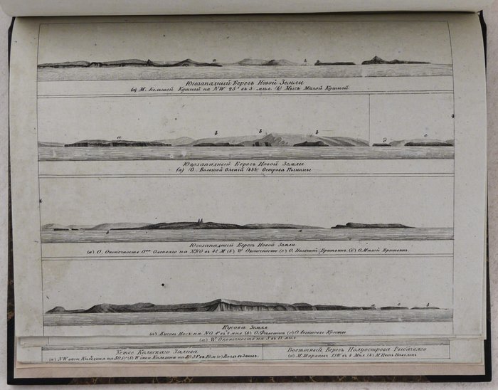
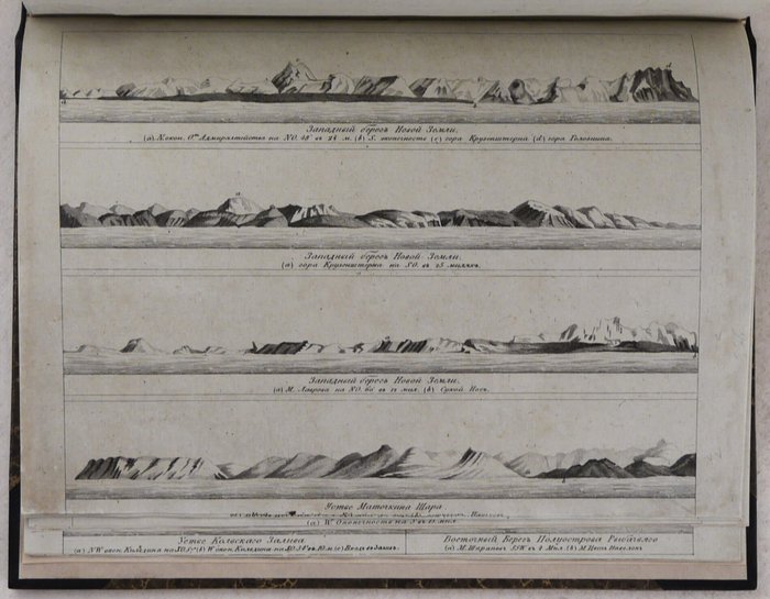
Coastal profiles at the rear of vol. 2:
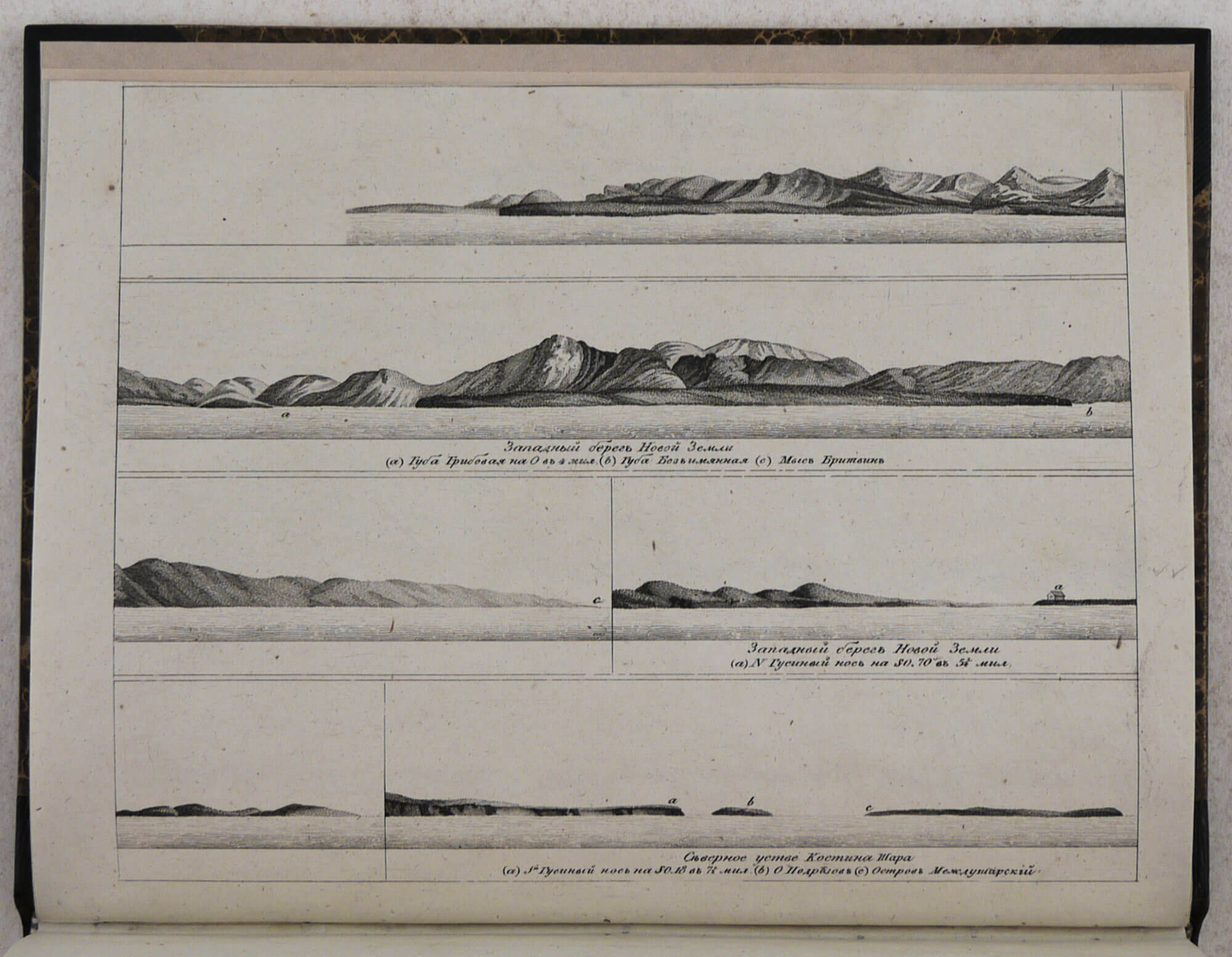
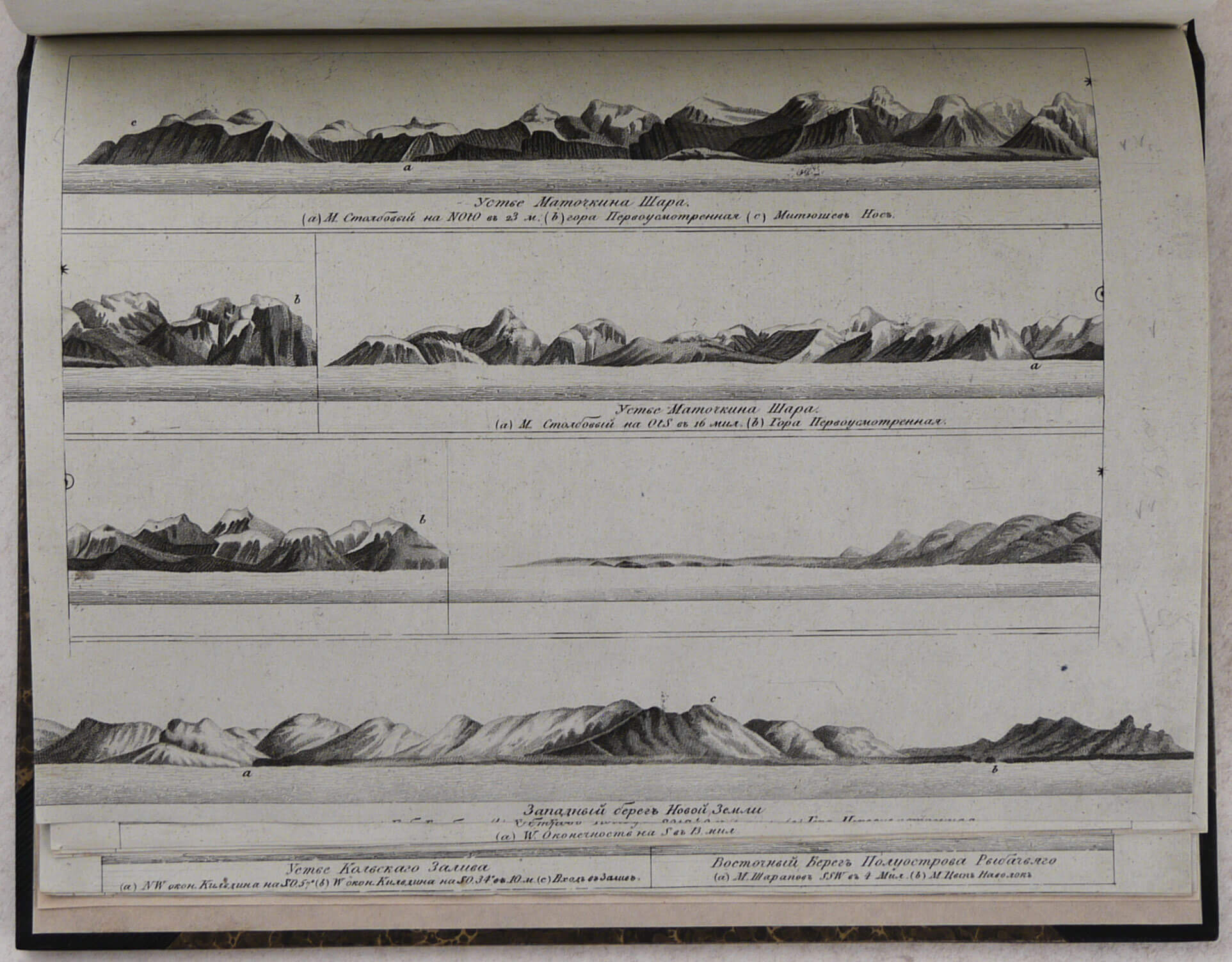
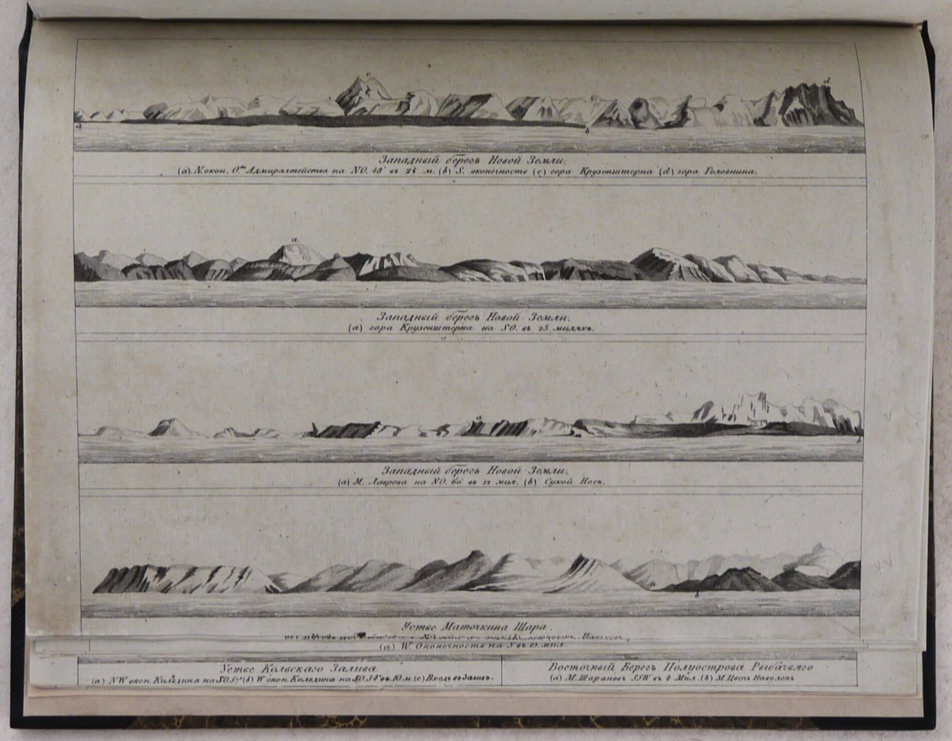
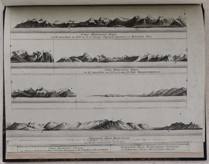
1) Zapadny bereg Novoi Zemli [3 profiles]. Ustye Matochkina Shara [Western coast of Novaya Zemlya – 3 profiles. Mouth of Matochkin Shar Strait];
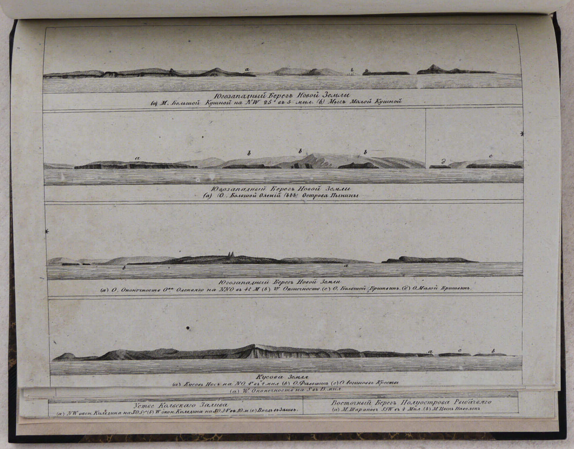
2) Yugozapadny bereg Novoi Zemli [3 profiles]. Kusova Zemlya [Southwestern coast of Novaya Zemlya – 3 profiles; Kusov Land];
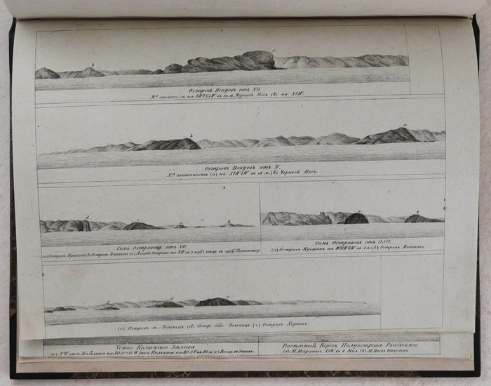
3) Bereg Laplandii ot Mysa Klyatny. Sem Ostrovov [Lapland coast from Klyatny Cape. Seven Islands];
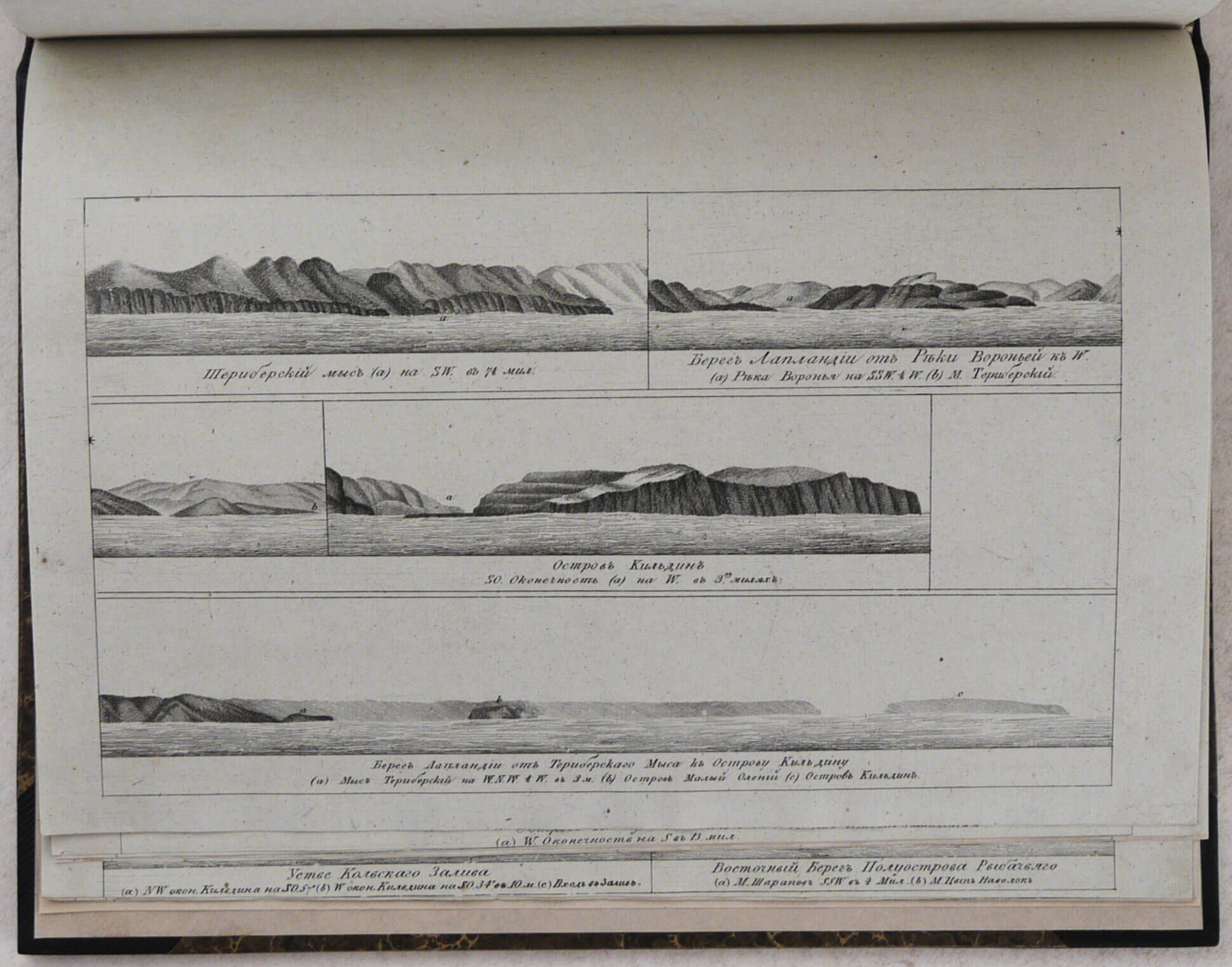
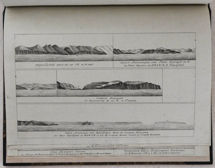
4) Teribersky Mys. Bereg Laplandii ot reki Voronyey. Ostrov Kildin. Bereg Laplandii ot Teriberskogo mysa k Ostrovy Kildinu [Cape Teriberka. Lapland coast from the Voronya River. Kildin Island. Lapland coast from Cape Teriberka to Kildin Island];
5) Ustye Matochkina Shara [2 profiles]. Zapadny bereg Novoi Zemli [Mouth of Matochkin Shar Strait – 2 profiles; West coast of Novaya Zemlya];
6) Ostrov Vaygach [2 profiles]. Ostrov Kolguyev [2 profiles] [Vaygach Island. Kolguyev Island – 2 profiles each];
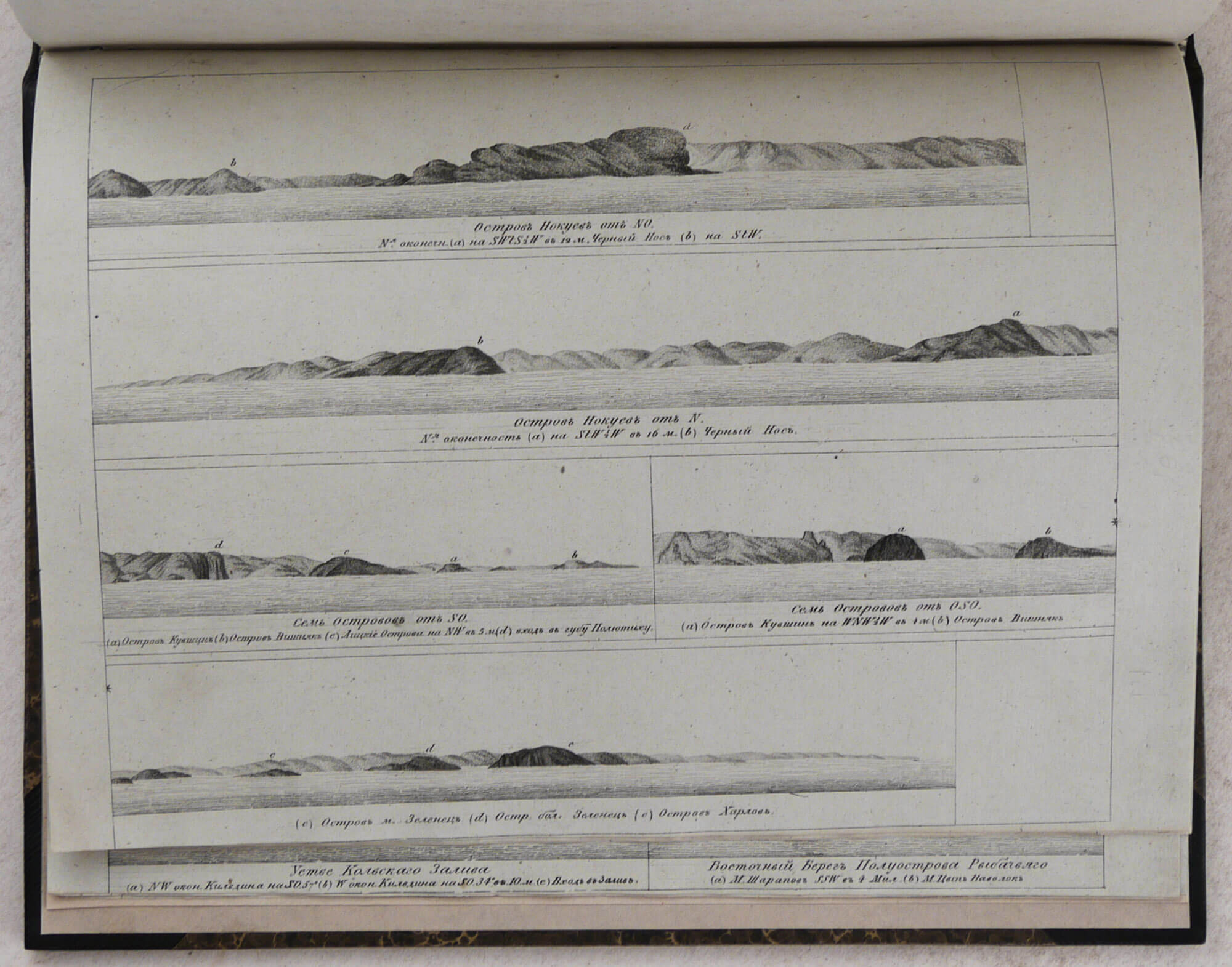
7) Ostrov Nokuyev [2 profiles], Sem Ostrovov [2 profiles]. Ostrov M. Zelenets [Nokuyev Island. Seven Islands – 2 profiles each. Minor Zelenets Island];
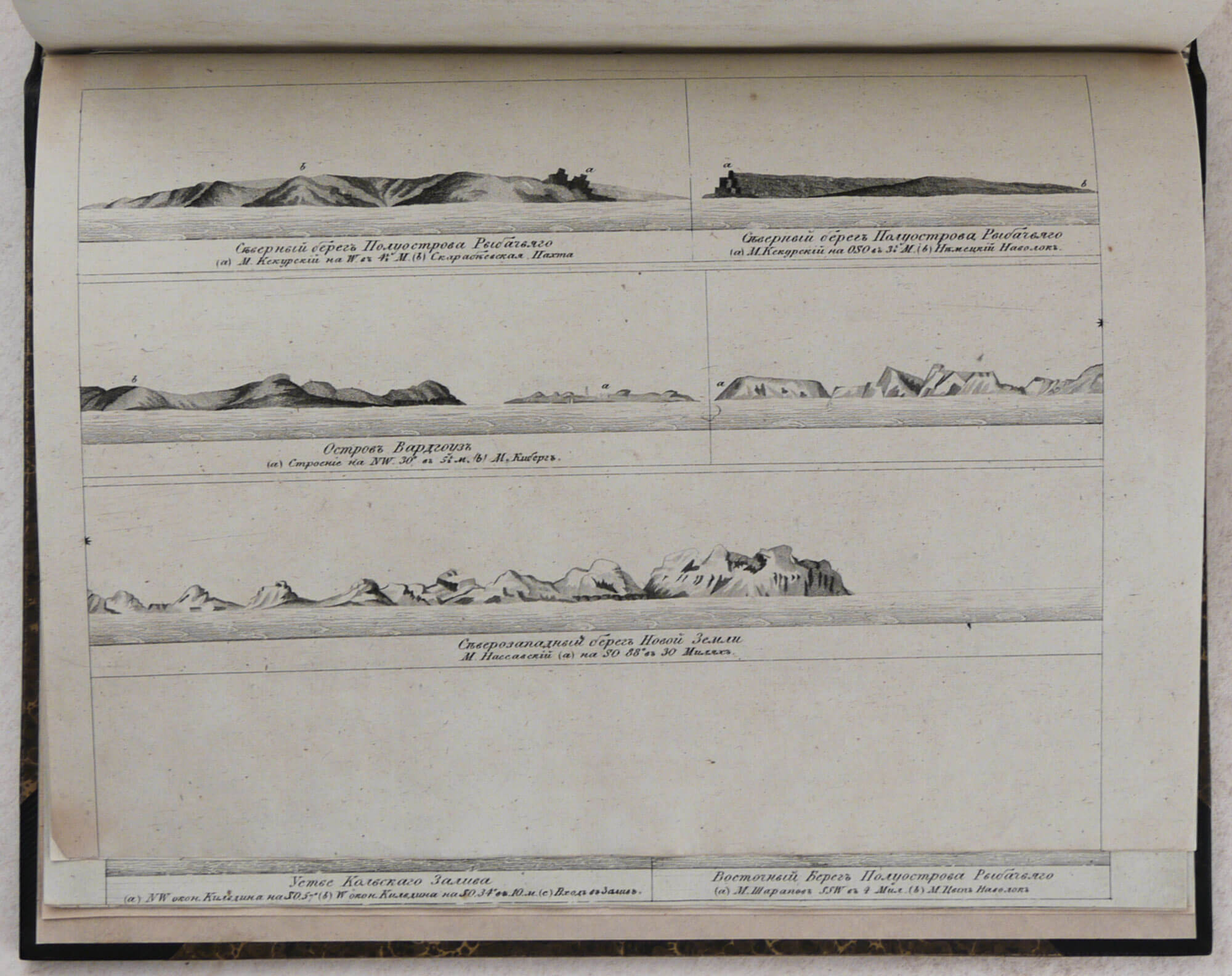
8) Severny bereg poluostrova Rybachyego. Ostrov Vardgouz. Zeverosapadnyi bereg Novoi Zemli [Northern shore of Rybachiy Peninsula. Vardoya Island. Northwestern coast of Novaya Zemlya];
9) Bereg Laplandii ot Chernogo Nosa. Bereg Laplandii ot ostrova Nokuyeva. Voctochnyi bereg Svyatonosskoy guby [Lapland coast from the Cherny Nos Cape. Lapland Cape from Nokuyev Island. East shore of the Svyatoy Nos Bay];
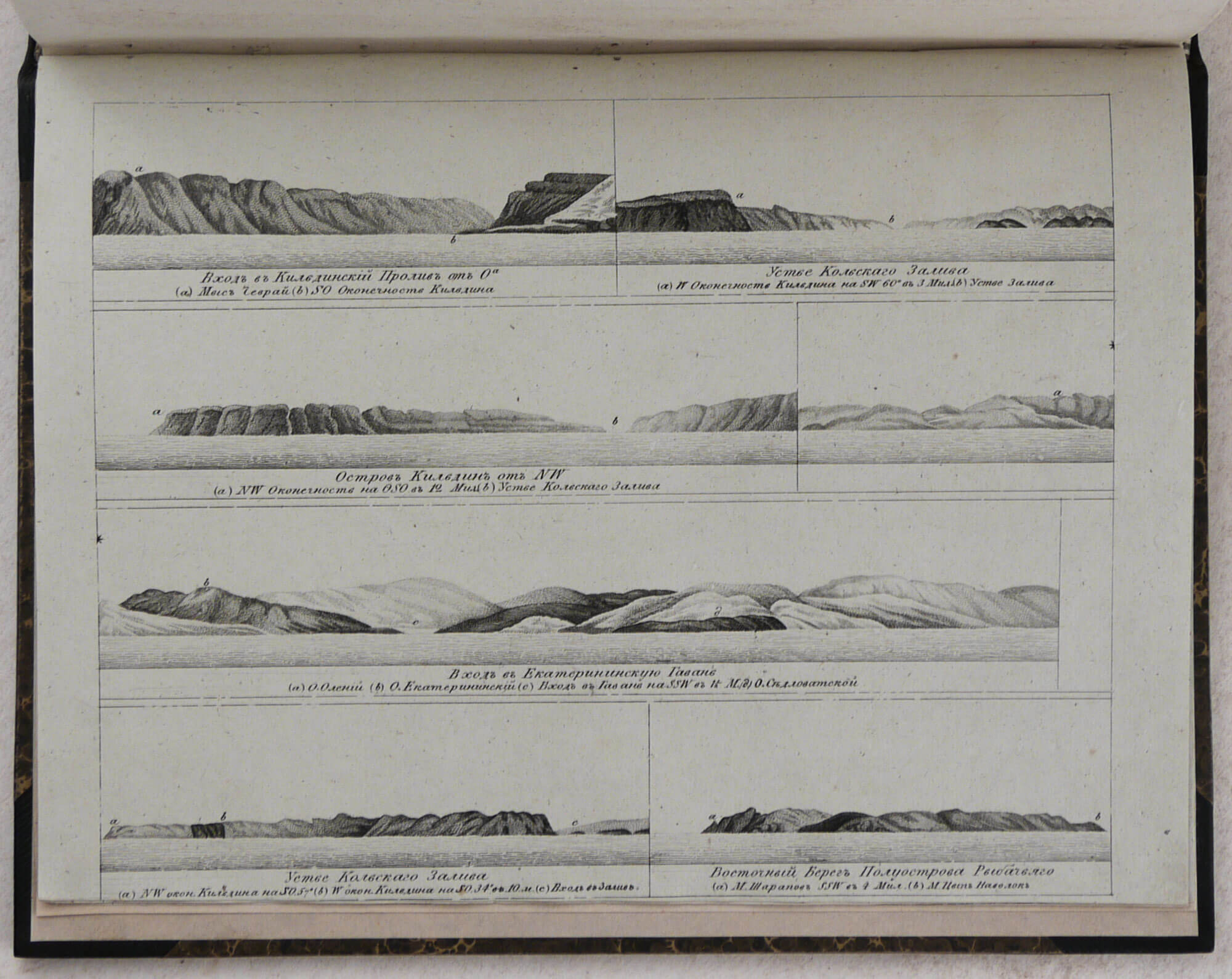
10) Vkhod v Kildinskiy proliv. Ystye Kolskogo Zaliva. Ostrov Kildin. Vkhod v Yekaterininskuyu gavan. Ustye Kolskogo Zaliva. Vostochnyi bereg Poluostrova Rybachyego [Entrance to Kildin Strait. Mouth of Kola Bay. Kildin Island. Entrance to Yekaterininskaya harbour. Eastern shore of Rybachiy Peninsula];
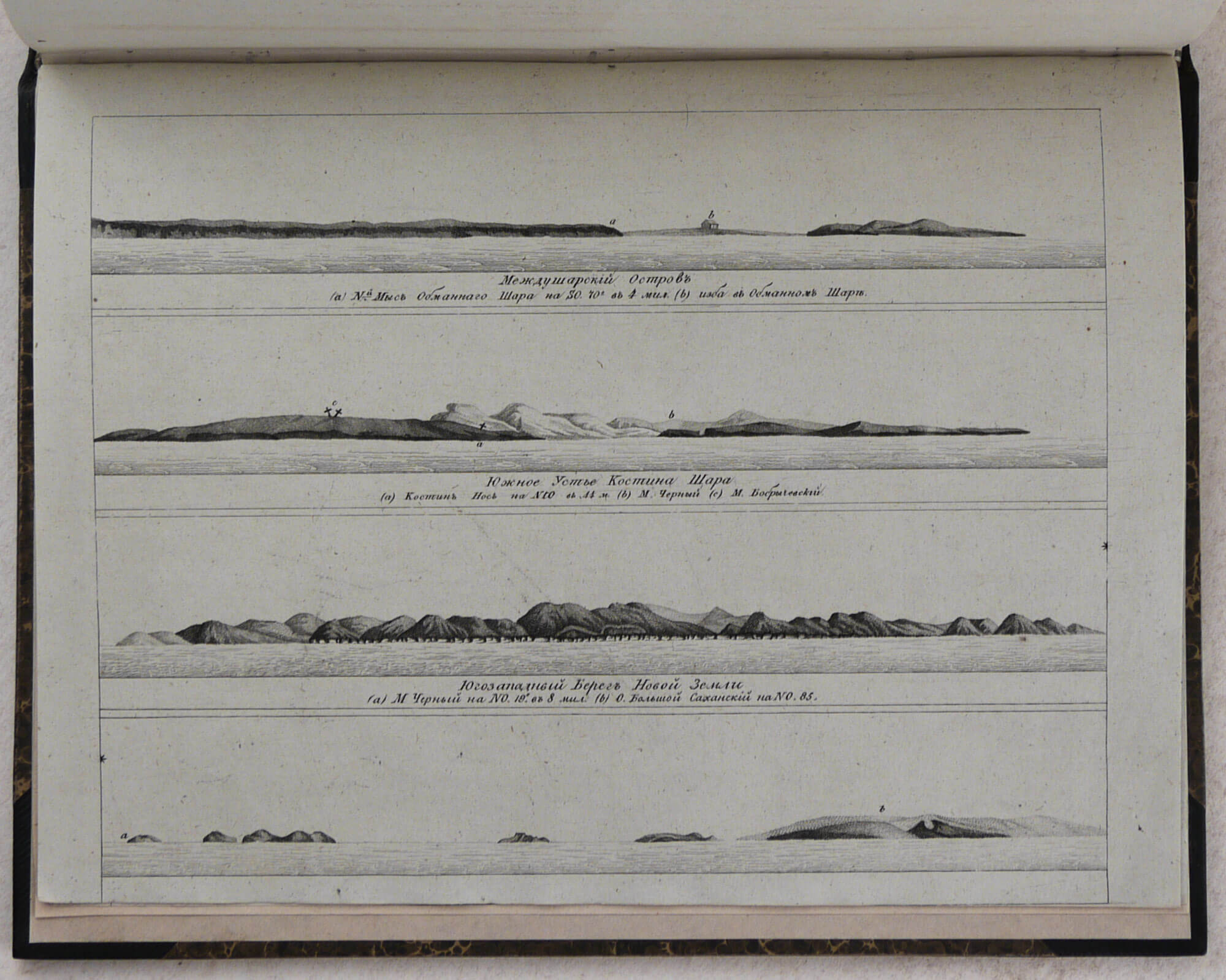
11) Mezhdusharsky Ostrov. Yuzhnoye ustye Kostina Shara. Yugozapadny bereg Novoi Zemli [Mezhdusharsky island. The south mouth of Kostin Shar Strait. Southwestern coast of Novaya Zemlya];
12) Zapadny bereg Novoi Zemli [2 profiles]. Severnoye ustye Kostina Shara [Western coast of Novaya Zemlya – 2 profiles. The northern mouth of Kostin Shar Strait];
13) Bereg okolo mysa Kuyskogo. Ostrov Sosnovets. Orlov Nos. Svyatoy Nos. Svyatonosskaya guba [Coast near Cape Kuysky. Sosnovets Islands. Cape Svyatoy Nos. Svyatoy Nos Bay];
14) Sem ostrovov [2 profiles]. Bolshoy Oleniy Ostrov [2 profiles]. Zimniye Gory [Seven Islands – 2 profiles. Big Oleniy/Deer Island. Winter Mountains].